|
|
HISTORY |
SOME HISTORICAL INTERESTThe name ALLESLEY is believed to derive from AELLE's Clearing or Wood. The district can lay no claim to any significant historical event. Records show that from 1129 to 1158 it was part of the estates of Ranulf, Earl of Chester. At that time it was in the extensive Forest of Arden, all of which has now disappeared from this area. 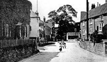 By permission of Coventry Libraries & Information Services There is reference in old records to an Allesley Castle but no real physical evidence can be found. It was supposedly on a high knoll of ground at the rear of Allesley Hall. The village lies on a low spur of higher ground between the east flowing streams of the River Sherbourne and Pickford Brook and was on the route of the London - Holyhead turnpike road before being by-passed in the 1960's. The old coaching road, which now forms the main street of the village, was built on this higher ground rather than the marshy ground of the two valleys before it traversed the heathlands of Packington and Bickenhill. The old Parish church at the extreme east end of the village is visible from a distance on 3 sides. In the 18th Century cattle fairs were held 7 times a year on the wide pavements in the centre of the village. To the north of the present village there were several large fields which were used as archery butts. Butt Meadow (to the east of present day Staircase Lane and now part of the Coundon Wedge fields) was used every Sunday morning when the men of the Parish were required to shoot so many quivers of arrows after church. Supposedly the ridges where their bows rested outside the church during services is still visible in the soft sandstone. The present Church Lane was known as "lovers lane" and the present Butt Lane was merely part of Washbrook Lane, the original Butt Lane being the first part of Staircase Lane adjoining the Butt Meadow. The 2 small rivers mentioned earlier have their sources only about 3 miles to the west, at Corley Moor, on the sides of the long narrow ridge forming the major north / south watershed of the Trent and Avon river systems. (Rain falling to the west of the ridge ends up in the North Sea whilst rain falling to the east of it finds its way to the Bristol Channel.) At this stage they are both very small, relatively clear streams. Indeed the name Sherbourne is said to derive from "Scir Burna"....clear stream. In 1935 and more on several more recent occasions the Sherbourne in these upper reaches around Allesley has dried up almost completely. Three miles further on the river enters the City of Coventry at Spon End where in earlier times its clear water was used in the famous "dyeing " processes for which Spon End and Coventry were well known. Unfortunately as it flowed on through Coventry it was not so clear because it was the only "sewer" ! |
WellsAs in all localities the people depended on wells or springs for their water supplies. The village of Allesley is believed to have depended on 2 main wells, one a Holy Well named St. Margaret's Well. This was alongside the main road just below the entrance to the former Paybody's House. The position is marked. Another was in front of Gable End, from where the pump was removed to put on St. Margaret's Well. There was also Lordswell, just out of the village at Park Lane near the present A45 Highway in a field called Lords Piece. It was said to be unfailing and became merely a drinking place for cattle. |
|
|